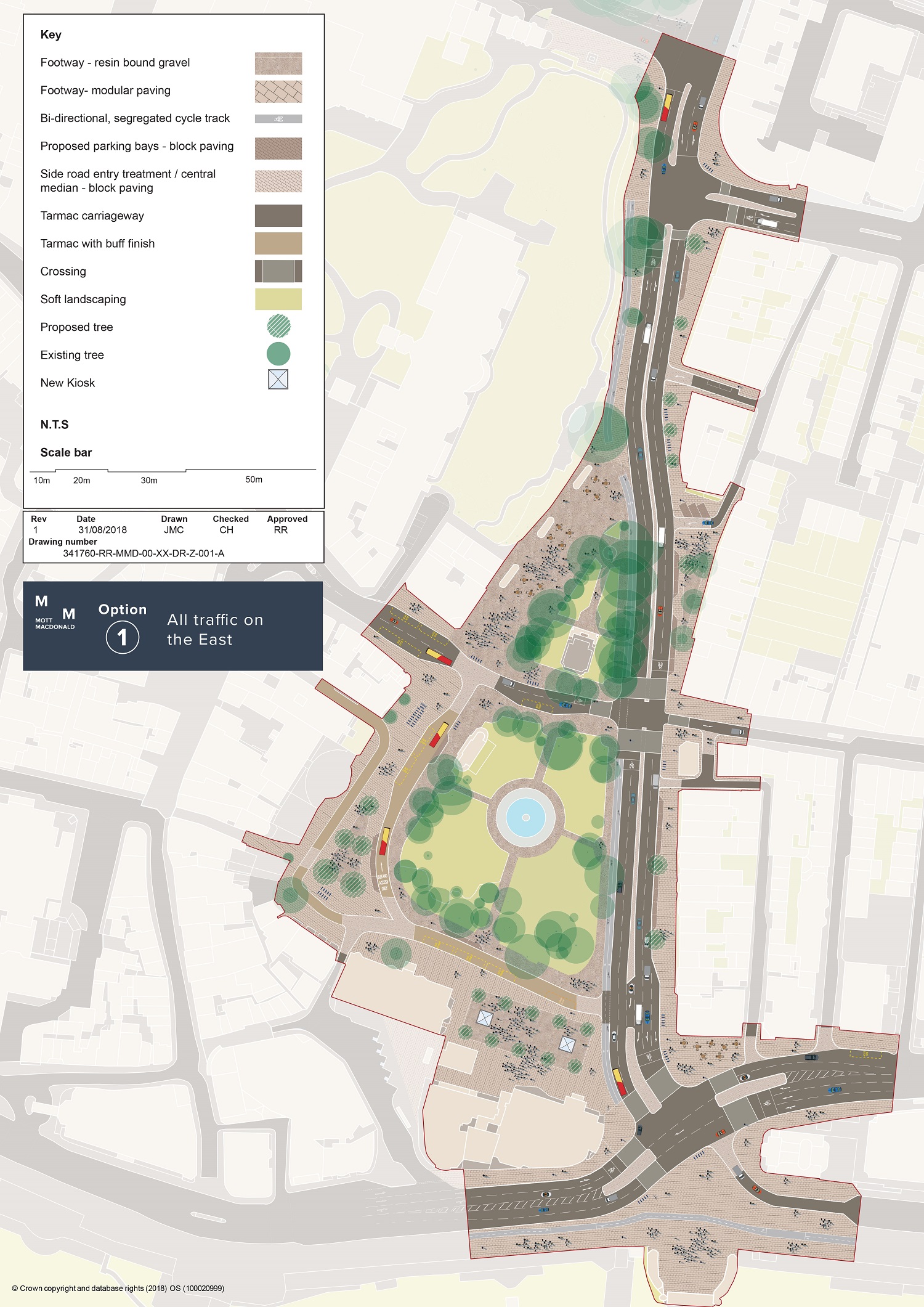
A preferred design for the Old Steine sees the Aquarium roundabout replaced with traffic lights and the road in front of the Royal Pavilion rerouted to the east of the war memorial.
Brighton and Hove City Council’s environment and transport committee is being asked to approve the plans, which were drawn up according to design objectives for the section of road from the Old Steine to the Palace Pier it agreed in June.
Transport officers have now come up with four different options. The second is to remove all traffic signals and replace them with informal roundabouts and crossings; the third to reroute buses to the west and replace the Aquarium roundabout; and the fourth the same as option three, but replacing the roundabout with lights.
A map of the preferred option, which scored highest against the design objectives, is the only one provided in the committee report and a consultation on just that option will start on October 15, subject to committee approval next Tuesday.
Chair of the Environment, Transport and Sustainability Committee, Councillor Gill Mitchell, said: “This is a significant opportunity to revitalise the Old Steine to Palace Pier area by improving the transport and public realm infrastructure.
“We want to make cycling, walking and public transport more attractive and viable options of transport, as well as improving the landscape to create an attractive, sustainable and safe green space.
“The existing junction is the most hazardous in the city and so it is important that we make improvements to make it safer and easier for all transport users.
“The area is also one of the main arrival points into the city and the redesign will improve and enhance the quality of the environment to reflect the city’s status as a key visitor destination.
“It is vital that local residents, businesses and users have their say on the proposals and give their own ideas on how the area can be improved. We want as many people as possible to take part in the next stage of the consultation.”
The project, the third phase of the Valley Gardens project on which work finally started last month, aims to improve connectivity to the city centre by simplifying the road layout, making improvements to the bus infrastructure, introducing a new cycle infrastructure and improving lighting and landscaping in the surrounding public spaces.
The existing area has the highest collision rate in the city, which has seen 124 collisions over five years, 23 of which resulted in serious injury. Conditions for cycling are particularly dangerous with cyclists disproportionately likely to be involved in a collision. The junction can also be confusing for drivers and pedestrians.
The preferred option being presented to committee next week includes proposals to significantly improve the seafront A23/A259 junction; construct a new, segregated north-south cycle lane linking Victoria Gardens with the Old Steine and seafront; and improve pedestrian crossings at the seafront and St James’s St.
Around the Old Steine area, there would be a simplified traffic layout with all traffic relocating to the east side in a dual carriageway layout, with the exception of a northbound loop for buses to the south-west of Steine Gardens.
Initial junction design and traffic light optimisation scenarios on the preferred option suggest better journey times would be achieved. Further optimisation and design of the preferred option will commence subject to approval at committee.
The green spaces around the area would be improved and made more accessible, allowing better access for pedestrians to the area’s green spaces, retaining the old tram shelters in situ but with new uses and enhancing the setting of the Royal Pavilion.
The council is conducting a two-stage public consultation to get the views of local residents, businesses and users as the project progresses. The first stage ran from May to June 2018 and sought to understand what people feel about the area and what they would like to see from the redevelopment.
The second stage of consultation, which will include two public exhibitions, will allow residents to give their views on the preferred design option and contribute their own ideas for the area.
If approved, the public consultation will run for six weeks from 15 October to 25 November. The responses collected will be essential in helping to develop a final preliminary design option and the results of the consultation will be reported back to the committee in January 2019.
A business case for funding for the project is being drawn up by council officers for submission to the Coast to Capital Local Enterprise Partnership. The business case will be presented to committee in November.


Public transport would be “more attractive and viable” if buses turned up when they were supposed to.
Very much liking the look of this, especially the large new pedestrian areas around the bottom of the Steine and in front of the Pavilion. Will be chaos to get it all built though.
The dual cycle track to the west of the Steine looks good, but why then does the plan show cycle waiting areas at both north and south bound at the junction with St James’s Street and at the junction with Marine Parade? Wouldn’t it be better to stop cyclists using the roads and make them use the cycle lanes provided at great expense for them?
As both a car driver and a cyclist I accept that at the moment legally cyclists cannot be forced to use cycle lanes provided but if they use the roads they should abide by the road traffic act and the Highway Code. So should drivers by abiding by recent changes on not moving into the ASL (Advanced Stop Line) area at traffic lights!
It’s taken so long to get this far – and there are even some, bizarrely, who object to the end of that terrible roundabout by the Palace Pier – but it should make the Steine a place to visit rather than avoid; this could, in turn, improve St. James’s Street.
Sorry, but losing the road by RBS and the Pavilion will only make things worse.