
A yellow weather warning has been issued by the Met Office as Storm Ali is forecast to hit the south coast on Thursday night – with another warning in place on Sunday too.
The first be aware warning, issued at about 10.30am this morning, says very strong winds will sweep eastwards across the south of the country from 6pm tomorrow.
The second, in place from 9am on Sunday to 9am on Monday, says there’s a small chance that “disruptive winds” will develop across England and Wales on Sunday.
The first warning says: “An area of strong winds is likely to develop across parts of Wales and southwest England during Thursday evening before spreading further eastwards across England. The strongest winds are then expected to clear into the North Sea early on Friday.
“Most likely is that we will see gusts of 45-50 mph in a few spots inland as well as more widely around exposed coasts. However, there is a small chance that stronger winds will develop in some areas with 60-65 mph gusts possible, particularly overnight into Friday across eastern England.
“The strong winds will accompanied by short-lived outbreaks of very heavy rain in places.”
The second warning says: “During Sunday there is the potential for a deep area of low pressure to develop and track over the UK bringing a spell of very strong winds and heavy rain.
“At this stage developments are very uncertain but there is a small chance of disruptive winds developing with parts of England and Wales currently looking most at risk.
“Any strong winds should gradually clear eastwards early on Monday with more settled conditions looking likely to follow next week.”
What to expect
- There is a slight chance of some damage to buildings, such as tiles blown from roofs or through falling trees and branches. This could also bring the chance of injuries and danger to life.
- There is a small chance of longer journey times or cancellations as road, rail, air and ferry services are affected
- There is a small chance that some roads and bridges could close
- There is a slight chance that power cuts may occur, with the potential to affect other services, such as mobile phone coverage
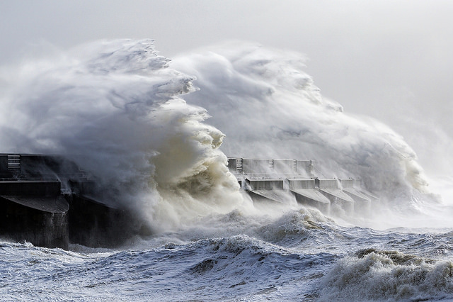
- There is a small chance that injuries and danger to life could occur from large waves and beach material being thrown onto sea fronts, coastal roads and properties


This will be storm Bronagh, not Ali.
Ali hit Northern Ireland and Scotland yesterday.
Since this story was written, a second low was forecast to deepen and was then named as a storm, ‘storm Bronagh’, the second of the autumn season. These names tend to add drama, where it’s not always due.
For Brighton and Hove, we do however get strong wind overnight, starting in the 30-40mph range but by midnight gusting to 50mph+ as squally rain showers track through.
The wind direction should be SSW initially on Thursday evening but veers to be more westerly after the rain clears in the early hours of Friday.
It’s that period of strong wind and heavy rain that justifies the Met Office Yellow Warning, although this is normal wind for the time of year.
Friday should dawn as a sunny but chilly day, and with a strong westerly or WSW wind continuing into the afternoon, with possible gusts of 40mph+.
A further low is expected to track through later on Saturday, bringing further overnight SW wind which probably lingers well into Sunday morning before it turns northerly as heavy rain clears.